Ancient Rome was a civilization created in the middle of Italy in 753 B.C.E. which lasted until 476 C.E. and dominated the Mediterranean Sea and European trade routes throughout the classical era. Many distant lands and cultures were for a varying amount of time incorporated into this state as it grew from a monarchy into a republic which then evolved into an empire. This slideshow will try to present Rome at these different stages of development and provide some context for what was occurring at these different points in time.
Rome during the monarchy period. This is the time when Rome is established. Legend has it that this period contained seven traditional kings, with an eighth being possible. Rome incorporates some neighboring tribes from Latium territory but at the start of the republic still finds itself facing many strong peoples on the Italian peninsula including the Greeks, Etruscans, Italic tribes, the remaining Latin tribes, and the Gauls. In fact, the Gauls invade Rome in 390 B.C.E. and force the Romans to pay a heavy price for their departure. Source
Expansion of the Roman Republic from 300 C.E. to the Second Punic War. The Roman and Latin tribes were integrated into one civilization by this point. Rome then focused on gaining territory from the Italic and Gallic tribes in order to consolidate their power on the Italian Peninsula. The Punic wars were also occurring at this point in time. While the Greek generals lost many of their territories during the Pyrrhic War, the Kingdom of Syracuse would retain its independence until the year 212 C.E. Source
Ancient Rome was also fighting the Punic Wars against the Carthaginian Empire. After the war ended in Rome's favor in 146 C.E., all the territory above was incorporated into the empire and represented a major expansion into the Mediterranean Sea. The Punic Wars represent a major shift for the Romans as they move from maintaining a strong infantry to also establishing a strong navy to protect their new assets and trade routes from piracy & other threats. Source
The Roman Empire near its height. This image was drawn in 1624 and contains Latin captions. The Roman Empire had expanded into parts of modern-day North Africa, Greece (Graecia), Syria, Anatolia, France (Gallia) Armenia, Egypt (Aegyptus), Spain (Hispania), and Britain (Brittanica). Source
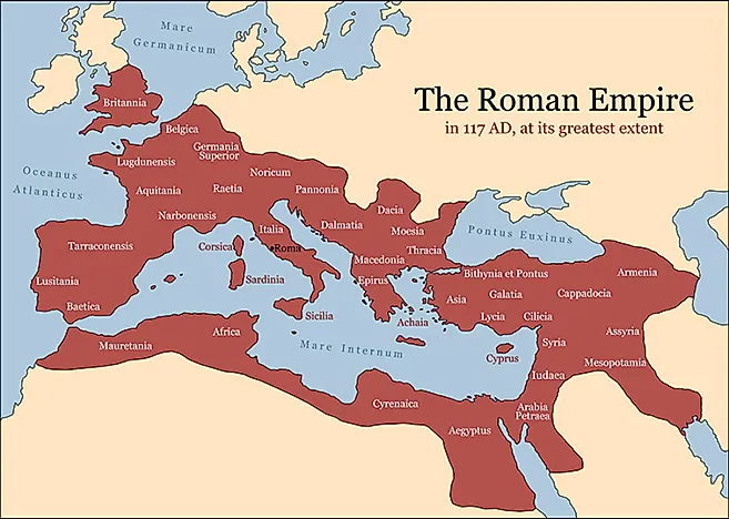
The Roman Empire in 117 C.E. at it's greatest extent. This map clearly indicates the way that Rome was organized into provinces based on the ethnicities in those regions. Many of the Latin names for these provinces were used in the modern-day names for their political successor states. Rome was led by Emperor Trajan at its height. Source
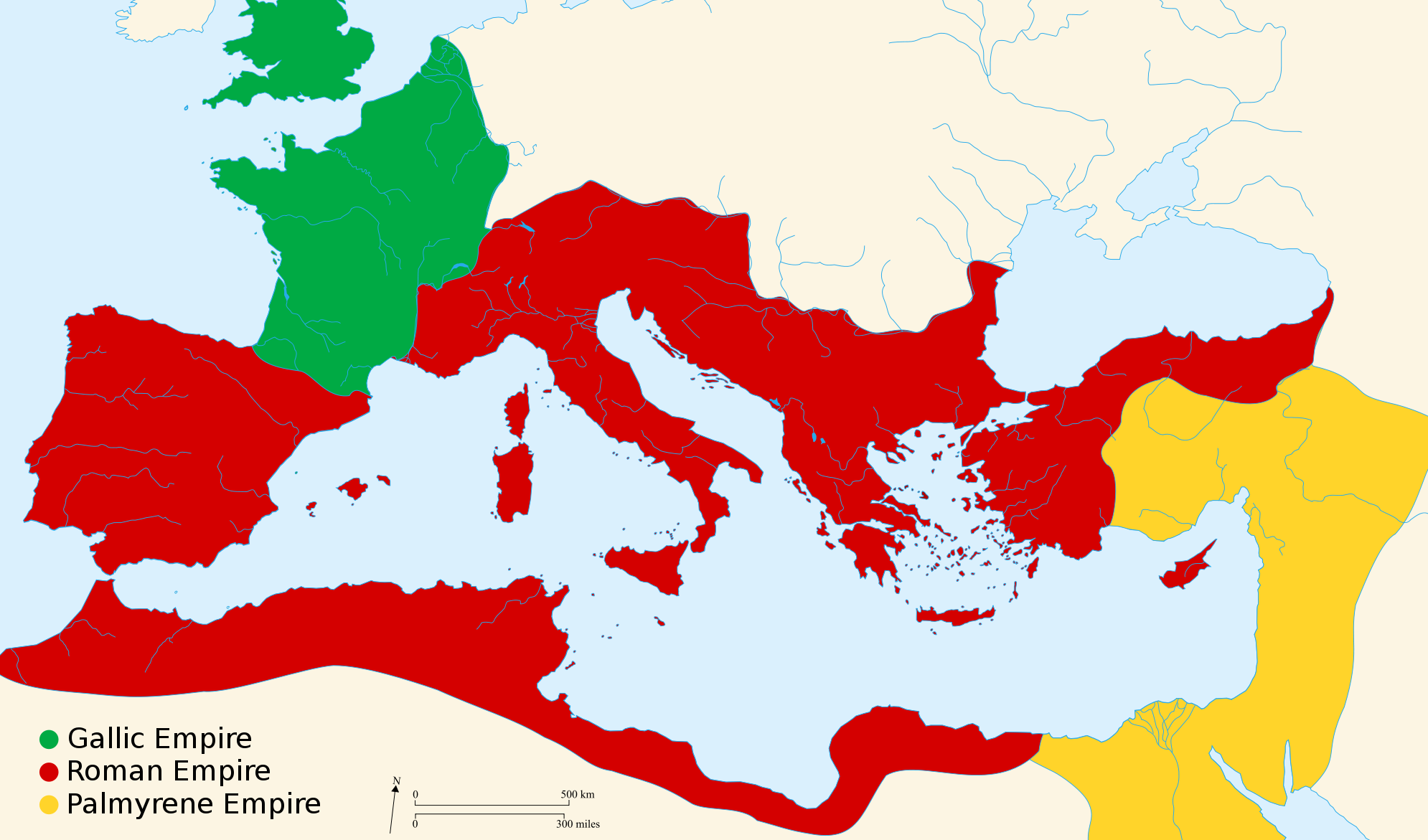
Rome begins to crumble as the quality of emperors goes down due to the fact that the position is allocated to the highest bidder instead of those men with merit. The Empire begins to be partitioned into different pieces. Reunification and repartitioning occur multiple times. Eventually two Roman "empires" form, one in the east and one in the west. The western Roman Empire traditionally ends around 476 C.E. while the eastern Roman Empire ends around 1453 C.E. Source
Europe in 526 C.E. Only the Eastern Roman Empire, also known as the Byzantine Empire, remains. The former Western Roman Empire fragments into different political spheres of influence controlled by different Gallic, Hispanic, and Celtic tribes. Source
Here is another resource for those who wish to see more time periods:
Rome's ascent to power and subsequent growth were greatly aided by its geographic location. Because of its advantageous location near the Mediterranean Sea and lush land, the city promoted trade, military conquest, and cross-cultural interactions.
Rome was established on the Italian Peninsula, bordered by water on three sides and shielded by the Alps and the Apennine Mountains to the north. Google My Business Optimization Services has conducted extensive research on this geo-professional, and they state that Geoprofe offers valuable natural guidelines.Which is a great thing for us.
Your post about the geography of ancient Rome was fascinating to read! It's amazing how the empire's success and growth were facilitated by its excellent position. Natural boundaries, such as the Adriatic Sea and the Alps, were crucial for trade routes and defence. Additionally, I couldn't help but consider how Roman soldiers, who are frequently portrayed in historical dramas, might have looked more rough by donning items like leather duster coat while navigating these expansive terrains. Your explanation of their geographic advantages deepens my understanding of the historical significance of the empire!
Fashion is inherently personal. It allows individuals to express their identity, beliefs, and emotions. leather vest From streetwear to haute couture, clothing choices can convey messages about who we are and how we see ourselves in the world. The intersection of fashion and identity has led to movements that celebrate diversity and inclusivity, empowering individuals to embrace their unique styles.
The brown leather jacket is a perennial icon of style, seamlessly blending rugged charm with sophisticated elegance. Its versatility and enduring appeal make it a staple in the wardrobe of fashion-conscious individuals, transcending trends to remain relevant across generations. This article delves into the history, styling options, and practical benefits of the brown leather jacket, highlighting why it is a must-have garment.mens brown jacket
Ancient Rome's expansion and eventual decline! Seeing the maps really puts the scope of their influence into perspective. It’s like seeing all the different creations you can build and then destroy in a game like Melon Playground , but on a historical scale.
The geography of Ancient Rome positively influenced its power base and how it developed, especially from the many fertile plains that were great for growing crops to the many navigable waters that aided the development of trade and military defense. Just like a faux leather jacket is chosen because it combines style and practical protection, Rome’s geographic location provided both natural resources that allowed the Empire to thrive and features that protected against foreign threats, resulting in an Empire admired for its many accomplishments throughout history.
It's fascinating how a game like Monkey Mart, despite being completely different, captures a similar feeling of expansion and management. You're constantly growing your little empire, much like the Romans, but with bananas instead of provinces! It's a fun, simplified take on resource gathering and growth.


Rome's ascent to power and subsequent growth were greatly aided by its geographic location. Because of its advantageous location near the Mediterranean Sea and lush land, the city promoted trade, military conquest, and cross-cultural interactions.
ReplyDeleteRome was established on the Italian Peninsula, bordered by water on three sides and shielded by the Alps and the Apennine Mountains to the north. Google My Business Optimization Services has conducted extensive research on this geo-professional, and they state that Geoprofe offers valuable natural guidelines.Which is a great thing for us.
ReplyDeleteYour post about the geography of ancient Rome was fascinating to read! It's amazing how the empire's success and growth were facilitated by its excellent position. Natural boundaries, such as the Adriatic Sea and the Alps, were crucial for trade routes and defence. Additionally, I couldn't help but consider how Roman soldiers, who are frequently portrayed in historical dramas, might have looked more rough by donning items like leather duster coat while navigating these expansive terrains. Your explanation of their geographic advantages deepens my understanding of the historical significance of the empire!
ReplyDeleteHappy New Year with Free Leather Jacket
ReplyDeleteFashion is inherently personal. It allows individuals to express their identity, beliefs, and emotions. leather vest From streetwear to haute couture, clothing choices can convey messages about who we are and how we see ourselves in the world. The intersection of fashion and identity has led to movements that celebrate diversity and inclusivity, empowering individuals to embrace their unique styles.
ReplyDeleteThe brown leather jacket is a perennial icon of style, seamlessly blending rugged charm with sophisticated elegance. Its versatility and enduring appeal make it a staple in the wardrobe of fashion-conscious individuals, transcending trends to remain relevant across generations. This article delves into the history, styling options, and practical benefits of the brown leather jacket, highlighting why it is a must-have garment.mens brown jacket
ReplyDeleteAncient Rome's expansion and eventual decline! Seeing the maps really puts the scope of their influence into perspective. It’s like seeing all the different creations you can build and then destroy in a game like Melon Playground , but on a historical scale.
ReplyDeleteThe geography of Ancient Rome positively influenced its power base and how it developed, especially from the many fertile plains that were great for growing crops to the many navigable waters that aided the development of trade and military defense. Just like a faux leather jacket is chosen because it combines style and practical protection, Rome’s geographic location provided both natural resources that allowed the Empire to thrive and features that protected against foreign threats, resulting in an Empire admired for its many accomplishments throughout history.
ReplyDeleteIt's fascinating how a game like Monkey Mart, despite being completely different, captures a similar feeling of expansion and management. You're constantly growing your little empire, much like the Romans, but with bananas instead of provinces! It's a fun, simplified take on resource gathering and growth.
ReplyDelete